(21 Aug 2025)
RESTRICTION SUMMARY:
ASSOCIATED PRESS
Nags Head, North Carolina – 21 August 2025
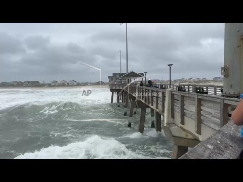
1. Mid pan, early morning view of waves from pier
2. Close-up fisherman on pier
3. SOUNDBITE (English) Daniel Irons, lives in Hatteras, North Carolina:
"Looking for birds, man, seeing what kind of pelagic birds get blown in with a storm, but yeah."
4. Close-up Irons looking through telescope
5. UPSOUND (English) Reporter asking question:
"You’re not worried about being out on a pier in the middle of a storm like this?"
6. SOUNDBITE (English) Daniel Irons, lives in Hatteras, North Carolina:
"Nah. (Reporter: Why not?) Not that bad."
7. SOUNDBITE (English) David Alan Harvey, Photographer from Nags Head, North Carolina:
"Safer here than anywhere else. (Reporter: I’m sorry?) Safer here than most other places, right ? This is this is nature at its best. This is a positive experience. Nothing negative about this."
8. Mid, person watching waves
9. Mid, sign of Jennette’s Pier
10. Back view of Kettner fishing
11. SOUNDBITE (English) Sebastian Kettner, from Clayton, North Carolina:
"Trying to catch a fish. Uh nothing doing so far though. (Reporter: Did this feel, I mean, a lot of people might say this is a little dumb?) Uh, where there’s water, there’s fish."
12. Wide, waves crashing on pier
13. Mid, video crews on pier
14. Various, people watching waves and getting caught in spray
15. Wide, waves
16. Various, waves crashing on beach
STORYLINE:
Hurricane Erin pounded the North Carolina coast with strong waves and gusty winds as it began to move out to sea Thursday. It was still considered dangerous for beachgoers along the U.S. East Coast.
Erin lost some strength Tuesday and dropped to a Category 2 hurricane as it moved northward, roughly parallel to the East Coast. However, its maximum sustained winds remained at 105 mph (169 kph) on Thursday. Erin could become a major hurricane again before finally weakening by Friday, the National Hurricane Center in Miami said.
The hurricane was about 210 miles (338 kilometers) east of Cape Hatteras, North Carolina, on Thursday and was moving north-northeast at 17 mph (28 kph).
Although the weather center was confident Erin would not make direct landfall in the United States, authorities have warned that water conditions along the East Coast remain dangerous. Beachgoers were cautioned against swimming due to life-threatening surf and rip currents.
Officials on a few islands along North Carolina’s Outer Banks issued evacuation orders and warned that some roads could be swamped by waves up to 20 feet (6 meters). By Wednesday evening, officials had closed Highway 12 on Hatteras Island as the surge increased and waves rose. Ocracoke Island’s connection to its ferry terminal was cut off.
AP Video shot by Allen G. Breed
===========================================================
Clients are reminded to adhere to all listed restrictions and to check the terms of their licence agreements. For further assistance, please contact the AP Archive on: Tel +44(0)2074827482 Email: info@aparchive.com.
Find out more about AP Archive: http://www.aparchive.com/HowWeWork
Twitter: https://twitter.com/AP_Archive
Facebook: https://www.facebook.com/APArchives
Instagram: https://www.instagram.com/APNews/
You can license this story through AP Archive: http://www.aparchive.com/metadata/youtube/33dae8a176b041b3aad330add9cff071
Author: AP Archive
Go to Source
News post in August 26, 2025, 3:07 pm.
Visit Our Sponsor’s:
News Post In – News


